


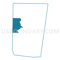
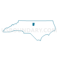
Voting District CX, Orange County, North Carolina
About
Outline

Summary
| Unique Area Identifier | 641071 |
| Name | Voting District CX |
| County | Orange County |
| State | North Carolina |
| Area (square miles) | 24.76 |
| Land Area (square miles) | 24.58 |
| Water Area (square miles) | 0.18 |
| % of Land Area | 99.27 |
| % of Water Area | 0.73 |
| Latitude of the Internal Point | 36.09166480 |
| Longtitude of the Internal Point | -79.22982220 |
Maps

Graphs
Select a template below for downloading or customizing gragh for Voting District CX, Orange County, North Carolina


Neighbors
Neighoring Voting District (by Name) Neighboring Voting District on the Map
- Voting District 09S, Alamance County, NC
- Voting District 103, Alamance County, NC
- Voting District 10N, Alamance County, NC
- Voting District 10S, Alamance County, NC
- Voting District 11, Alamance County, NC
- Voting District CA, Orange County, NC
- Voting District CG, Orange County, NC
- Voting District EF, Orange County, NC
- Voting District OG, Orange County, NC
Top 10 Neighboring County Subdivision (by Population) Neighboring County Subdivision on the Map
- Township 10, Melville, Alamance County, NC (16,681)
- Cheeks township, Orange County, NC (9,313)
- Township 9, Thompson, Alamance County, NC (8,532)
- Bingham township, Orange County, NC (6,527)
- Cedar Grove township, Orange County, NC (5,222)
- Township 11, Pleasant Grove, Alamance County, NC (4,575)
Top 10 Neighboring Place (by Population) Neighboring Place on the Map
Top 10 Neighboring Unified School District (by Population) Neighboring Unified School District on the Map
Top 10 Neighboring State Legislative District Lower Chamber (by Population) Neighboring State Legislative District Lower Chamber on the Map
- State House District 64, NC (80,704)
- State House District 50, NC (73,491)
- State House District 63, NC (70,427)
Top 10 Neighboring State Legislative District Upper Chamber (by Population) Neighboring State Legislative District Upper Chamber on the Map
Top 10 Neighboring 111th Congressional District (by Population) Neighboring 111th Congressional District on the Map
- Congressional District 4, NC (826,878)
- Congressional District 13, NC (753,104)
- Congressional District 6, NC (714,412)
Top 10 Neighboring Census Tract (by Population) Neighboring Census Tract on the Map
- Census Tract 111.01, Orange County, NC (8,028)
- Census Tract 213, Alamance County, NC (6,057)
- Census Tract 111.02, Orange County, NC (5,844)
- Census Tract 112.03, Orange County, NC (5,301)
- Census Tract 108.01, Orange County, NC (5,025)
- Census Tract 212.05, Alamance County, NC (4,636)
- Census Tract 212.04, Alamance County, NC (4,280)
- Census Tract 220.02, Alamance County, NC (4,276)
- Census Tract 212.07, Alamance County, NC (3,086)